Land surveying is an age-old practice that has played a pivotal role in shaping the world as we know it today. From the earliest civilizations to the modern digital age, the history of land surveying is a fascinating journey through time.
Follow along with us as we explore the history of land surveying, highlighting key milestones and advancements that have paved the way for Ambit Consulting.
Ancient Beginnings
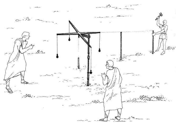
The roots of land surveying can be traced back thousands of years to ancient civilizations such as the Egyptians, Mesopotamians, and Greeks. These early surveyors were primarily concerned with creating boundaries, assessing land taxes, and planning construction projects. They used tools, including ropes, plumb bobs, and sighting poles, to measure distances and angles with varying degrees of accuracy.
One of the most remarkable surveying achievements of antiquity is the construction of the Great Pyramid of Giza. The Egyptians demonstrated remarkable precision in aligning the pyramid’s sides with the cardinal points of the compass, a feat that still baffles archaeologists today.
Roman Advancements
The Romans, known for their engineering prowess, made significant contributions to land surveying as well. They developed the groma, a device consisting of intersecting wooden arms with plumb bobs at the ends, which allowed for more accurate land measurement and straight-line construction.

The Middle Ages and Renaissance
During the Middle Ages, surveying knowledge was preserved and advanced by Islamic scholars, who further developed mathematical techniques for land measurement. However, it was the Renaissance that brought a resurgence of interest in the field.
Figures like Leonardo da Vinci and Leon Battista Alberti applied geometric principles to surveying, laying the groundwork for more precise methods that we still use at Ambit today.
The Surveyor’s Tools Evolve
The 18th and 19th centuries marked a significant turning point in the history of land surveying. Innovations like the theodolite, a precise angle-measuring instrument, and the development of the triangulation method for mapping large areas, greatly improved surveying accuracy.
And, the introduction of latitude and longitude as standardized reference points enhanced global navigation and mapmaking.
The Digital Revolution
The late 20th century brought about a digital revolution in land surveying. Global Positioning System (GPS) technology, initially developed for military purposes, became a game-changer for surveyors worldwide. GPS allows for highly accurate positioning and mapping, transforming land surveying into a faster and more efficient process.
The advent of Geographic Information Systems (GIS) also revolutionized data management and analysis, making it easier to store, analyze, and share surveying data.
Modern Land Surveying
Today, land surveying continues to evolve with the integration of advanced technologies like LiDAR (Light Detection and Ranging), drones, and 3D laser scanning. These technologies enable surveyors to capture incredibly detailed data for a wide range of applications, from land development and construction to environmental monitoring and disaster management.
Additionally, the field of land surveying has expanded beyond Earth’s surface, with surveyors contributing to the exploration and mapping of other celestial bodies, such as Mars and the Moon.
The history of land surveying is a testament to human ingenuity and our relentless pursuit of precision and accuracy. From the humble beginnings of ropes and plumb bobs to the cutting-edge technology of today, land surveyors have played a vital role in shaping our world and expanding our understanding of it.
Ambit Consulting Land Surveying
Just like our ancestors, at Ambit Consulting, we continue to explore new frontiers and embrace ever-advancing tools and techniques. The future of land surveying holds exciting possibilities and we’re eager to be a part of it.Interested in embracing the future with us? Click here to learn how to join our team!
